
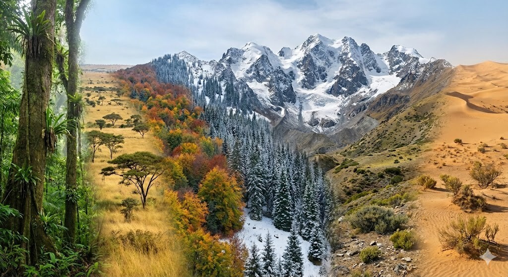
The Macroscope: Reading the World from a Single Point
An introduction, for the general reader, to the idea beneath the Macroscope — the research program at the heart of the Canemah Nature Laboratory.
A microscope makes the very small visible. A telescope makes the very far visible. A macroscope is meant for the things that are too large, too slow, and too interconnected to see all at once — a watershed, a season, an ecosystem, a life of paying attention to one piece of ground. You cannot hold any of those in a single glance. But you can build an instrument that gathers them, patiently, from where they actually happen.
The Macroscope is that instrument. And underneath all of its sensors, maps, and archives, it rests on one quiet move: the world arrives as coordinates, and coordinates become meaning.
The world speaks in locations
Think about how any fact about the living world first reaches you. A warbler sings — from a particular branch. A photograph is taken — at a particular corner of a meadow. A weather station reports — from a particular rooftop. A footstep on a survey lands — at a particular point on a trail. Before any of it means anything, it is simply a place: a latitude and a longitude. That is the one language the physical world reliably speaks, and everything the Macroscope does begins by listening for it.
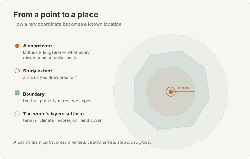
Figure 1. A coordinate becomes a known place when we draw its extent and let the world's reference layers settle over it.
Places are the nouns
The first thing we do with a coordinate is decide whether it matters. When it does, we curate it into a place. Curating is a deliberate, human act: we draw the place's study extent — a center point and a radius, and in time a true boundary — and then let the world's reference layers settle over it. The shape of the terrain and the range of its elevations, pulled from a global digital model of the land's surface. The local climate. The ecoregion it belongs to. The vegetation that covers it.
A dot on the map becomes a named, characterized, stewarded location — one with a history, neighbors, and a place in a hierarchy of larger places. Places are the nouns of the Macroscope: the stable, known things everything else refers back to.
Surveys are the verbs
Knowing a place is never finished; it is something you do, again and again. A survey is a bounded trip through space and time — a morning walk, a drone flight over a meadow, a round of repeat photographs from fixed points, a slow acoustic listen through a spring night. Each survey carries its own path across the ground and its own moment in the calendar.
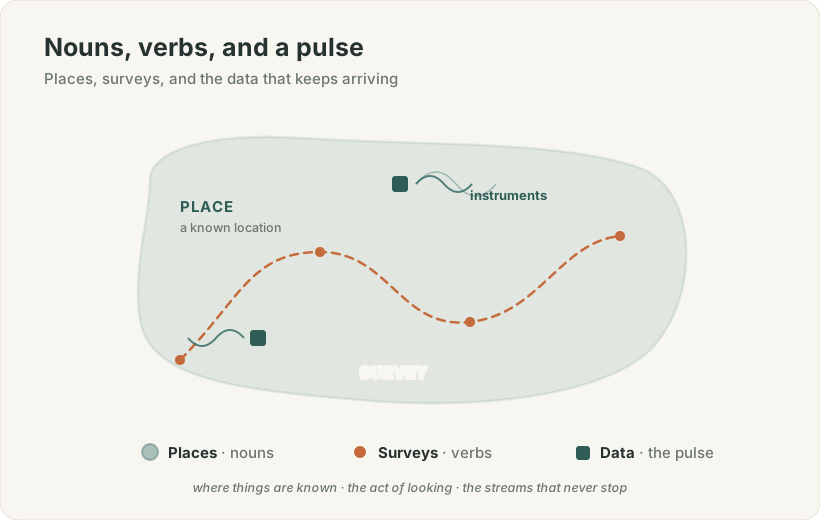
Figure 2. A place is where things are known; a survey is the act of looking; the data is the pulse that keeps arriving.
A survey can happen anywhere. If it lands inside a place we already know, it belongs to that place, and its observations gather there. If it lands out in open country, it can later be promoted — its route and extent becoming the seed of a brand-new curated place. This is how the known world grows in the Macroscope: not all at once, but one field trip at a time, each one turning a stretch of the unknown into somewhere we now understand.
Data is the pulse
Between the surveys, the instruments never rest. Weather stations breathe out temperature, wind, and rain. Air monitors track the invisible. Acoustic recorders catch birdsong and tally species through the dark. Cameras and 360-degree rigs deposit imagery that can be walked through later like a room. And a personal record — health, work, reading, the ordinary evidence of a life — accrues alongside the rest.
This is the pulse: the streams that keep arriving whether or not anyone is watching. On their own, such streams are just numbers adrift. The Macroscope grounds them — a place gives a reading its where-it-belongs, a survey gives it an occasion, and the instrument that produced it gives it a provenance. A measurement is never left floating free of the world that made it.
Nothing is sealed off
A closed system would be a diary. The Macroscope is meant to be a window, so it federates outward — reaching to the world's shared reference libraries. It draws on citizen-science networks like iNaturalist and eBird for what is alive at a location, on global elevation models for the lay of the land, on the great open encyclopedias for reconciling one place's many names, and on regional weather meshes for context that no single backyard station could supply.
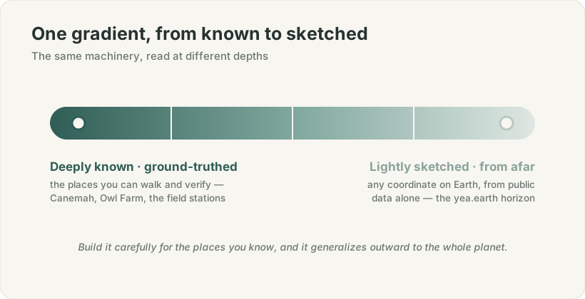
Figure 3. One gradient runs through everything: from the places you can walk and verify, to any coordinate on Earth sketched from public data alone.
And this reveals the organizing idea that ties the whole program together. There is a single gradient running through it, from deeply known to lightly sketched. At one end sit the places you can walk and ground-truth — Canemah, Owl Farm, the university field stations — rich, vetted, deeply instrumented. At the other end sits the very same machinery, pointed at any coordinate on Earth, with only public data to draw on. Build the tools carefully for the places you know intimately, and they generalize outward to the whole planet without being redesigned. The care you take at home becomes the reach you have everywhere.
The four faces of where I am
Stand at any coordinate and it turns four faces toward you at once. There is EARTH — the climate, the geology, the landscape, and the water that shape everything above them. There is LIFE — the biodiversity, the natural history, the ecosystems, and the seasons threading through it. There is HOME — the building, making, dwelling, and the quiet systems by which we turn a patch of habitat into a place of our own. And there is SELF — the observer, whose health, people, learning, and story are themselves part of the record.
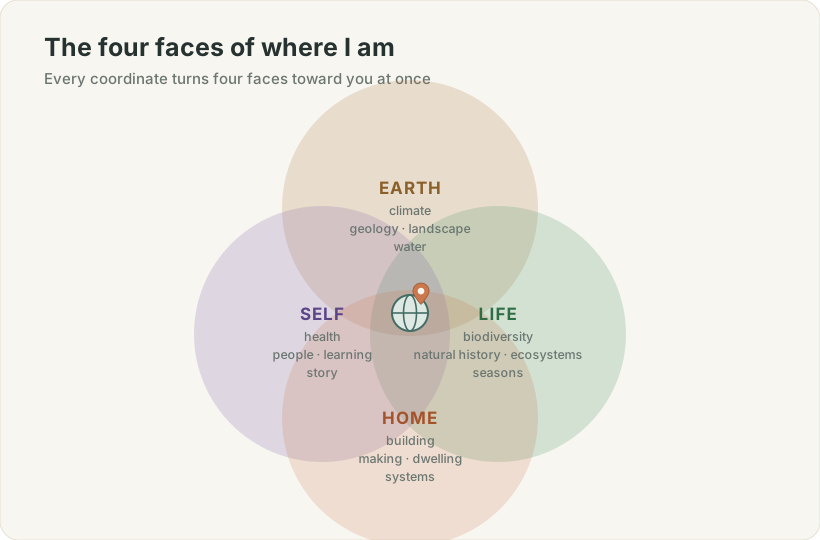
Figure 4. EARTH, LIFE, HOME, and SELF are not separate worlds — they are four faces the same point turns toward you at once.
The Macroscope holds all four at the same point, because in the real world they were never actually separate. The weather is also the bird's morning; the built home is also a habitat; the observer's own day is woven through the data they gather. Keeping them together, at one location, is what lets a question cross freely between them — how does a warm spring move a bloom, and the bloom move a pollinator, and the whole cascade register in a life lived nearby?
One architecture, read at different depths
Here is the elegant part, the reason a lifetime program can be described in a single breath. It is all one architecture, read at different depths.
A coordinate is the atom. A place is a coordinate you have come to know. A survey is the act of coming to know it. The data is what you learn. And the world's reference layers are the context you resolve it against. EARTH, LIFE, HOME, and SELF are simply the four faces that same point turns toward you — weather, biodiversity, built habitat, and self, all meeting on the ground beneath your feet.
That is what the Macroscope has quietly become: not a database of readings, but a way of paying a naturalist's kind of attention — the patient, place-rooted, everything-connects-to-everything kind — at the scale of a planet. It starts, as every good observation does, by standing in one spot and asking what is here.
Explore the Macroscope yourself at macroscope.nexus.*